1000000
Type of resources
Available actions
Categories
Topics
Topics
INSPIRE themes
Keywords
Contact for the resource
Provided by
Formats
Representation types
Update frequencies
Scale
pubblicaAmministrazione
-

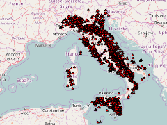
Mappa di calore superficiale dell'Italia
-

testo Eugenio
-
Mappa di calore superficiale dell'Italia
-

Many documents are defining a context for geothermal exploitation in a country. As the administrative levels and the geometry of that “geothermal exploitation context” could differ from one country to another a geothermal management area class has been defined. Dataset FAKE built to demonstrate, with a larger dataset, some analytic functionalities.
-

Surface Heat Flow Contour Map of Italy
-

Temperature Isoline at 2 km depth
-

Temperature map at 2 km depth (below ground level) of Italy
-

Industries involved in geothermal activities refer to all companies that produce components both for power production and the direct use of heat
-

Exploration and production licenses and (projected) power production
-
Surface Heat Flow Map of Italy
 GeothermCatalog